Seeing as one thing we've been able to rely on for the last few weeks is the weather, I decided to take my eight year old for her first long distance cycle ride.
We hadn't made any definite plans for a route but the plan was to head to the Forth and Clyde canal at Craigmarloch and then decide where to go from there. We initially intended to maybe retrace our tracks and head home that way but things turned out a wee bit differently.
So, at 7.15 p.m. we left Carrickstone and headed over the hill down through Dullatur. We went under the Glasgow - Edinburgh railway line and past the route of what remains of the Antonine Wall which was the furthest and most northerly boundary of the Roman Empire. The security that the wall gave from hostile tribes to the north probably allowed the foundations of the settlements which eventually became Cumbernauld the name of which comes from the Scots Gaelic comar nan allt, meaning the meeting of the waters as, geographically, from its high point in the Scottish central belt burns (streams) flow west to the River Clyde and east to the River Forth.
Antonine Wall
The Antonine Wall is a stone and turf fortification built by the Romans across what is now the Central Belt of Scotland, between the Firth of Forth and the Firth of Clyde. Representing the northernmost frontier barrier of the Roman Empire, it spanned approximately 39 miles (63 km) and was about ten feet (3 m) high and fifteen feet (5 m) wide. Security was bolstered by a deep ditch on the north side. The barrier was the second of two "great walls" created by the Romans in Caledonia. Its ruins are less evident than the better known Hadrian's Wall to the south.
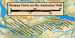
Construction began in AD 142 at the order of Roman Emperor Antoninus Pius, and took about twelve years to complete. Pressure from the Caledonians may have led Antoninus to send the empire's troops farther north. The wall was protected by sixteen forts with a number of small fortlets between them; troop movement was facilitated by a road linking all the sites known as the Military Way. The soldiers who built the wall commemorated the construction and their struggles with the Caledonians in a number of decorative slabs, twenty of which still survive. Despite this auspicious start the wall was abandoned after only twenty years, and the garrisons relocated back to Hadrian's Wall. In 208 Emperor Septimius Severus re-established legions at the wall and ordered repairs; this has led to the wall being referred to as the Severan Wall. However, the occupation ended only a few years later, and the wall was never fortified again. Most of the wall and its associated fortifications have been destroyed over time, but some remains are still visible. Many of these have come under the care of Historic Scotland and the UNESCO World Heritage Committee.
Abandonment
The wall was abandoned after only twenty years, when the Roman legions withdrew to Hadrian's Wall in AD 162 (although there is evidence to suggest that they left the wall in AD 158/60, its reliability is unclear), and over time reached an accommodation with the Brythonic tribes of the area who they fostered as the buffer states which would later become "The Old North". After a series of attacks in AD 197, Emperor Septimius Severus arrived in Scotland in AD 208 to secure the frontier, and repaired parts of the wall. Although this re-occupation only lasted a few years, the wall is sometimes referred to by later Roman historians as the Severan Wall. This led to later scholars like Bede mistaking references to the Antonine Wall for ones to Hadrian's Wall.
Nothing much remains of the wall any more apart from a noticeable ditch and mound at some points
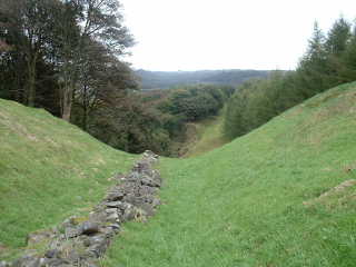
and the remains of a fort at Barrhill above Kilsyth

but it was really strange travelling along the remains especially at that time of night when you could imagine the long gone Roman soldiers lighting the watch fires and getting ready for their eveing post.

So, we headed down the hill to Craigmarloch basin on the Forth and Clyde canal and decided to head east along the towpath to the bridge at Wyndford. We had a wee snack and I had a chat with a guy who was doing some fishing at the bridge having caught a couple of wee perch using floated worms.
From here, we headed up the raod which seemed to be closed for some reason till we came to the back of Wardpark North Industrial estate and were able to pick up a path again along the Antonine wall and behind Cumbernauld airfield till we came to Weterwood golf course which was designed by Severiano Ballesteros.
Then we followed the golf paths to behind the Westerwood hotel and into the residential development of Wetserwood which is part of Cumbernauld before heading home to Carrickstone.
The round trip took about 2 hours and the section along the Antonine wall behind the airfield was new to me. I wouldn't recommend this route after prolonged rain but it was pretty enjoyable in the gloaming of the almost summer spring evening made even more so by the company of my wee daughter who never complained once.
What a wee star !


No comments:
Post a Comment