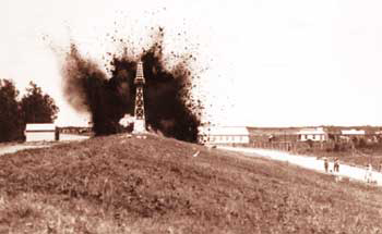
The images on tv were quite stunning if that is the right word for it with the army blowing up levees in Cairo Illinois to protect the town at the sacrifice of 130 000 acres of farmland to divert and release water. Around New Orleans they have deployed 2 flood diversion systems to try and divert water in Lake Pontchartrain.
Apparently it is the worst flooding since the " Great flood of 1927 "
and the river is running over three miles wide having broken a levee at the weekend to submerge an airfield. The flood waters still have 1000 miles to go before they reach the Gulf of Mexico and further devastation is expected. Apparently 12% of the oil refineries in America are threatened by this flood which would have a major impact on availability if peoples worst fears were realised
The floods are being blamed on high snowfall in Minnesota over the winter which is now melting coupled with recent severe rainfall.
The Guardian Newspaper had this to say about how climate change is affecting large areas of the U.S.A.
"It's kind of a hydrological perfect storm," said Chris Vaccaro, a spokesman at the national weather service headquarters in Washington. Forecasters had been predicting flooding since last November because of a combination of heavy snowfall in midwestern states such as Minnesota, the source of the Mississippi, and severe rain storms further south.
"It's too much precipitation in too short of a time and in the wrong places," Vaccaro said. "It is the confluence of vast amounts of precipitation in terms of melting snowfall and rain, and then also the rain-swollen Ohio river flowing into the already swollen Mississippi."
American scientists have been warning for years that climate change is influencing extreme weather events. A US government report in 2009 predicted an increase in the number and severity of extreme weather events – heavy snows and rainfall in the mid-west and droughts in the south-west – due to climate change.
North Dakota and Minnesota have seen record flooding for each of the last three years. Meanwhile, southern parts of the US, from Texas to New Mexico and California, are reporting intense droughts this year.
The areas along the Mississippi have seen a marked increase in floods over the last 20 years, said Peter Gleick, president of the Pacific Institute for Studies in Development, Environment and Security, who briefed Congress on the flooding on Monday.
"All along the river, the Mississippi is reaching unprecedented flood levels," Gleick said. "We are now moving into a situation where all weather and storm events are, to some degree, influenced by human-induced climate change. The links between climate change and extreme events can not be ignored."
In the case of the Mississippi, however, the flood risks are compounded by bad city planning and a century of trying to squeeze rivers into tighter spaces through the levee system.
"Since 1993, we have seen huge numbers of new homes and business built on the flood plain despite recommendations never to do that again," said Gleick. "I think what we are seeing along the Mississippi is all of those things: climate change, bad planning, bad development and inappropriate levees."
Here is a short video which showing the extent of the flooding
I also found this from a bit of a self styled climate change Guru. The guy really seems to take it all very seriously as you can see from his presentation.


No comments:
Post a Comment